


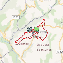
69620-StLaurentOingt-150801_01

adye
User

Length
6.9 km

Max alt
438 m

Uphill gradient
204 m
Km-Effort
9.6 km

Min alt
320 m

Downhill gradient
208 m
Boucle
Yes
Creation date :
2015-08-01 00:00:00.0
Updated on :
2015-08-01 00:00:00.0
1h31
Difficulty : Easy

FREE GPS app for hiking
 SityTrail
IGN / Geographical institutes
SityTrail Plus
The world is yours!
About
Trail Walking of 6.9 km to be discovered at Auvergne-Rhône-Alpes, Rhône, Val d'Oingt. This trail is proposed by adye.
Description
Tour de Saint-Laurent d'Oingt (Bourg, Cave coopérative, chapelle Mt Joli, Vernier)
NB : peu de route, peu d'ombre
Positioning
Country:
France
Region :
Auvergne-Rhône-Alpes
Department/Province :
Rhône
Municipality :
Val d'Oingt
Location:
Saint-Laurent-d'Oingt
Start:(Dec)
Start:(UTM)
620955 ; 5088948 (31T) N.
Comments